U.S.
NOAA’s winter outlook favors wetter conditions across the South and East
NOAA’s 2026–27 winter outlook favors a warmer North and wetter South and East. Here is what the seasonal forecast does—and does not—say.
What to know
- NOAA’s forecast covers December 2026 through February 2027 and describes seasonal probabilities, not the timing of individual storms.
- Wetter-than-average conditions are favored across the southern tier and East Coast; warmer-than-average temperatures are favored across much of the North.
- The agency expects drought to improve or end in several regions, while warning that heavy precipitation can create flooding and mudslide risks in some places.
- Local National Weather Service forecasts, watches and warnings remain the right tools for decisions about an approaching storm.
NOAA’s outlook for December 2026 through February 2027 favors wetter-than-average conditions across the southern United States and along the East Coast. It also favors warmer-than-average conditions across much of the northern United States. The agency says El Niño is a major influence on those broad seasonal odds. None of that tells a household when its next storm will arrive or whether its town will see more snow: those are questions for shorter-range forecasts and local alerts.
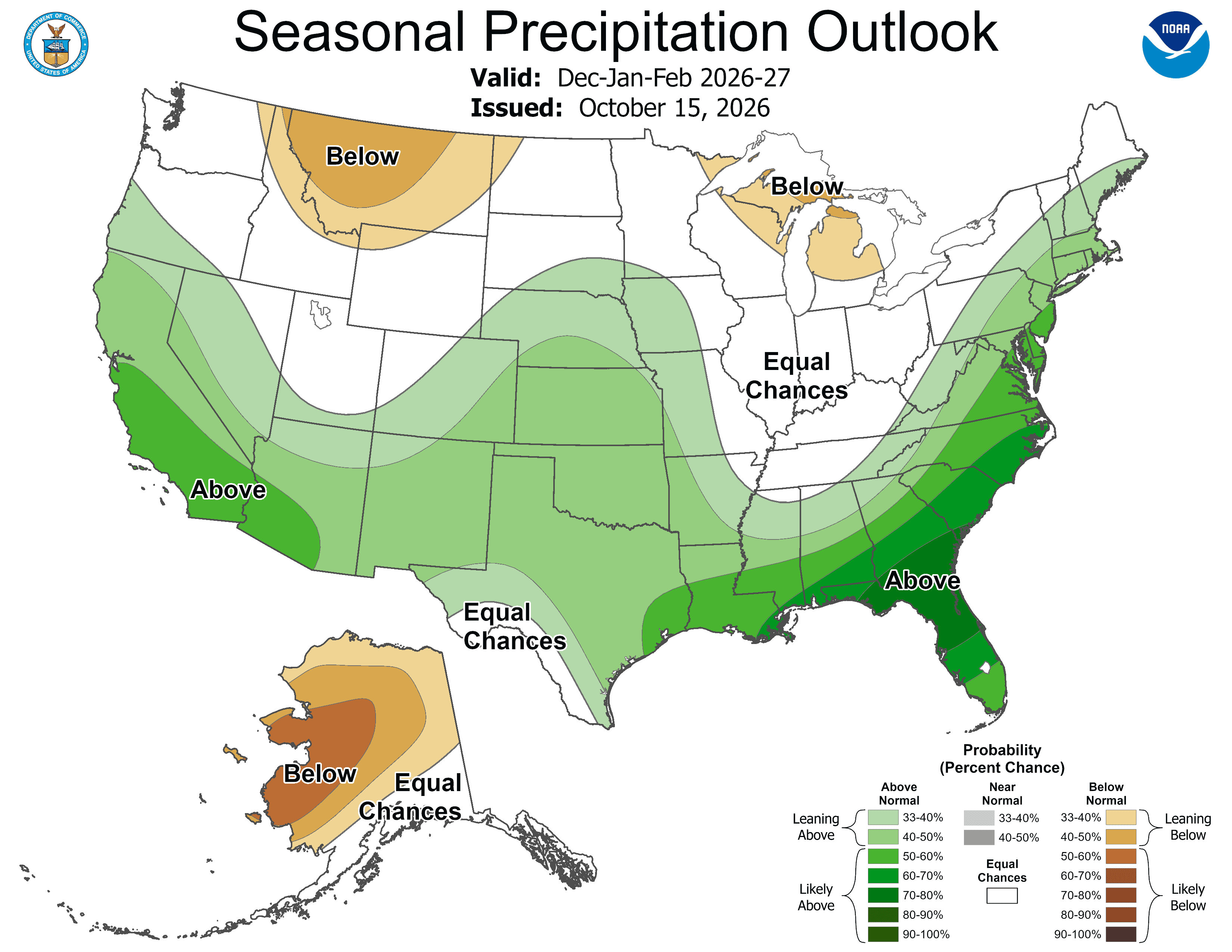
The National Oceanic and Atmospheric Administration announced the outlook on October 15. Its precipitation map shows the strongest tilt toward above-normal precipitation in parts of the Southeast and nearby East Coast, with other favored wet areas across the southern tier. The map is an outlook for the *total* precipitation over three months. It is not a forecast for a particular day, a promise of flooding, or a prediction that every storm will bring rain rather than snow.
Where the outlook points
NOAA favors above-average seasonal precipitation from the Southwest across the southern tier to the Southeast, as well as along the Eastern Seaboard. Its release identifies elevated odds of drier-than-average conditions in parts of the northern Mountain West and Great Lakes, much of Alaska, Hawaii and some western Pacific islands. Other locations fall into an “equal chances” category because the forecast does not strongly favor one of the three outcomes.
That phrase can be misunderstood. “Equal chances” does not mean the winter will be average; it means the outlook offers no strong tilt toward above-, near- or below-average precipitation for that location. Likewise, the green shading on the map does not specify inches of rain or snow. It describes the probability that the season’s total precipitation will finish above the local historical average. A location can experience a damaging storm even if its three-month total finishes near average. Conversely, a wet seasonal total does not mean every week will be wet.
NOAA’s temperature outlook separately favors warmer-than-average conditions in northern California, the Pacific Northwest, Midwest, Mississippi Valley, much of the East, Alaska, Puerto Rico and the U.S. Virgin Islands. Parts of the Southeast, including Florida, lean toward near-normal temperatures. Hawaii and much of the Southwest have equal chances among the three temperature categories. Temperature and precipitation are separate measurements: a wetter regional outlook should not be read as a snowfall forecast.
Why El Niño matters, and what remains uncertain
NOAA identifies a very strong El Niño as a key influence on this winter’s outlook. Ken Graham, director of the National Weather Service, said in the agency’s release that it is likely to shift the jet stream southward and eastward, tilting the odds toward stormier weather across the South. That is a broad explanation for the seasonal pattern, not a track for any one storm. Other weather patterns will still affect what individual communities experience.
Seasonal forecasting is useful because households, utilities, farmers and emergency managers can consider risks before winter begins. But it has a different job from a five-day forecast. NOAA says its seasonal maps give the likelihood of above-, near- or below-average temperatures and precipitation. The agency explicitly says the outlook does not project seasonal snowfall accumulation: snow forecasts generally are not predictable more than a week ahead. A warmer-than-average season can still contain dangerous cold spells, and a wetter-than-average season can include long dry stretches. Those are consequences of how a multi-month average works, not contradictory forecasts.
The map itself carries an important date and time frame: it was issued October 15, 2026, and is valid for December, January and February. Readers should check the latest version before making winter plans because NOAA updates its three-month outlook monthly. NOAA said the next update after this release is scheduled for November 19. A change in the next outlook would be new information, not proof that the earlier forecast promised certainty.
Drought relief and excess-water risks
NOAA anticipates drought improving or ending across portions of the Southwest, Southern Great Plains, Southeast and East Coast. Its drought outlook also favors drought developing or worsening in parts of the northern Rockies and parts of Oregon and Washington. Those forecasts concern regional conditions over time; they should not be treated as a field-level prediction for a particular farm or garden.
More precipitation can help dry areas, but it can also bring hazards. Graham warned that heavy rain or snow on dry soil can fuel flash floods and mudslides. A household near a flood-prone road, a steep slope or an area recovering from drought needs more than a broad green region on a map to understand its exposure. Local forecasts and warnings can identify approaching precipitation; local emergency-management guidance can explain evacuation routes and neighborhood risks. The seasonal outlook is a prompt to review those resources, not a substitute for them.
For homesteads and small farms, the practical question is which preparations make sense regardless of the exact winter total. Checking drainage around buildings, protecting stored feed and keeping essential supplies accessible can reduce disruption if wet weather arrives. Those are planning implications, not claims that NOAA has predicted damage to a specific property. Agricultural choices should also reflect local conditions and advice from the relevant extension service, rather than a national seasonal map alone.
What households can do now
The National Weather Service advises people to prepare homes, workplaces and vehicles before winter storms. Its winter preparation guidance calls for flashlights and batteries, a way to receive weather information, food and water that do not require cooking, needed medication, first-aid supplies, and arrangements for pets and farm animals. It also highlights the possibility of losing heat, power or phone service. A household can use that list to identify gaps before a storm is in the forecast, then adjust for its own people, animals and climate.
Heat and generator safety deserve special attention. The Weather Service says an emergency heat source must be used with proper ventilation and fire precautions; it warns never to run a generator in an enclosed space. Working smoke and carbon-monoxide detectors are part of the same plan. For a home that relies on a well pump, electric fencing or refrigerated medicine, a power outage may create a different priority from one in an apartment. The national guidance supplies a starting point; the household still has to map its own dependencies.
Drivers should also check a vehicle before the season. The Weather Service recommends keeping a charged phone and supplies such as blankets, a flashlight, extra clothing, food and a shovel in a winter vehicle kit. Its advice is especially relevant for anyone who regularly travels between home, work and outbuildings or checks on animals away from the main house. When a winter storm is imminent, road conditions and official travel advice matter more than a seasonal outlook issued months earlier.
For readers building a plan, EasternPrepping’s winter readiness guide for home and homestead turns the forecast into a checklist for alerts, outages, supplies and animals. Its household preparedness starting guide offers a broader framework for organizing those steps. Those guides are practical companions to the NOAA forecast, not additional weather predictions.
What happens next
NOAA plans to refresh the seasonal outlook on November 19. Until then, readers can view their local National Weather Service forecast and alerts and check back as winter approaches. The agency’s new Probabilistic Precipitation Portal is intended to show ranges and probabilities for snow, ice and rain when shorter-range forecasts become available. NOAA also said the Weather Service will use “Particularly Dangerous Situation” wording in select Blizzard and Ice Storm Warnings for rare, high-confidence events with exceptional risk. Those products address approaching weather; they should not be confused with the three-month outlook.
This article explains published federal guidance and its limits. It does not include an independent interview, a local forecast or a prediction of a particular storm.