World
Vance reaches 105 mph off Mexico: why its next turn is difficult to forecast
The 5 p.m. Eastern advisory puts Vance at Category 2 and forecasts major-hurricane strength tonight. Dangerous surf may reach Mexico even while the center stays offshore.
What to know
- Vance had maximum sustained winds of 105 mph in the 21:00 UTC advisory, making it a Category 2 hurricane. Major-hurricane strength was a forecast for tonight, not its confirmed status at that time.
- The NHC reported no coastal watches or warnings, but said interests along southwestern Mexico should monitor the storm.
- Swells could create life-threatening surf and rip currents along southern and southwestern Mexico beginning this weekend and continuing into next week.
- Forecast confidence is limited because cooler ocean water, wind shear and the storm's structure could change both its strength and path.
Hurricane Vance strengthened to 105 mph off Mexico's Pacific coast Friday, and the National Hurricane Center said it could become a major hurricane overnight. The immediate message for coastal readers is more specific than a frightening category number: dangerous surf is expected along parts of southern and southwestern Mexico, while the future strength and track remain unusually difficult to pin down.
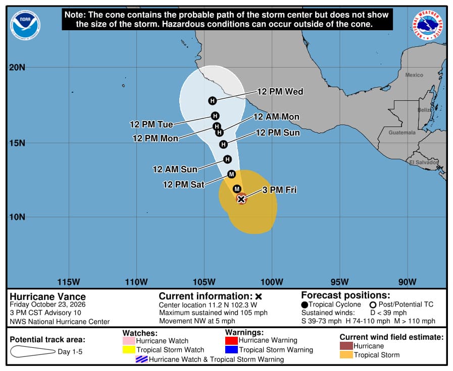
The official assessment used here is Advisory 10, issued October 23 at 21:00 UTC, or 5 p.m. Eastern and 3 p.m. Central Standard Time. It placed Vance about 425 miles south-southwest of Acapulco and 555 miles south-southeast of Manzanillo. No coastal watches or warnings were in effect in that advisory. That was the status at the stated time, not a guarantee that coastal alerts cannot change later.
The hurricane was moving northwest at only 5 mph. Its slow motion matters because the amount of time its center spends over different ocean conditions could strongly affect its intensity. Forecasters expect a complicated sequence of strengthening and weakening, rather than a smooth climb to a single peak.
What changed Friday afternoon
The NHC's afternoon forecast discussion described a better-organized inner core, including a defined eye surrounded by the central area of thick clouds. Satellite estimates supported raising the official intensity to 90 knots, expressed in the public advisory as 105 mph. The estimated central pressure was 971 millibars.
That combination explains the strengthening headline. But forecasters also saw fragmented outer rainbands and cloud features suggesting dry air southwest of the central cloud mass. A clearer eye therefore did not eliminate competing influences on the hurricane. The discussion treated its future intensity as a low-confidence forecast, even while predicting additional strengthening in the near term.
The distinction is useful when comparing weather updates. An observed or estimated current wind speed describes the storm at the advisory time. A stronger number in the forecast table describes a future possibility in the official forecast. Posting the future number as though it has already occurred would overstate what the observations establish.
Why the ocean beneath Vance matters
The storm's eye was moving toward an area with sea-surface temperatures near 27 degrees Celsius and reduced ocean heat content, according to the NHC discussion. Forecasters expected that patch of comparatively cooler water to interrupt the ongoing strengthening. They nevertheless forecast Vance to reach major-hurricane strength before that interruption.
Surface temperature and ocean heat content are related but different measures. The surface tells forecasters about the uppermost water, while heat content helps describe how much warm water is available below it. A slow storm can remain exposed to unfavorable ocean conditions longer than a faster-moving one. In this case, the forecast specifically linked the duration over that cooler patch to the intensity outlook.
The exact track is therefore part of the intensity problem. The NHC said a path to the right of its forecast would leave the center over colder water longer, while a path farther left would reduce that time. Small differences on a map can consequently change the environment the hurricane experiences, even before any question of coastal proximity arises.
Wind shear adds another complication
The discussion also expected increasing southwesterly vertical wind shear over the hurricane. Wind shear describes changes in wind with height. A tropical cyclone's circulation can become less efficiently organized when winds at different levels push its structure out of alignment.
Forecasters identified a possible feedback between weakening and movement. A stronger storm that remains vertically aligned could move slowly north-northwestward and then northward. A weaker system whose circulation becomes more separated with height could initially move farther northwest before turning north. The NHC favored a forecast in which Vance stays vertically connected, while acknowledging a weaker alternative.
That is why individual model lines should not be read as separate promises. The forecast discussion compared different representations of the hurricane's strength and structure, not simply different opinions about where an otherwise identical storm would go. The official forecast represents the forecasters' judgment across those competing scenarios and the available observations.
A changing intensity forecast, not a fixed landfall prediction
The Advisory 10 forecast table called for winds of 120 mph at 06:00 UTC Saturday and 115 mph at 18:00 UTC Saturday, both within major-hurricane territory. It then showed weakening, followed by some renewed strengthening after roughly two days and another weakening period later in the five-day outlook.
Those figures are forecast values tied to particular times. They are not measured winds at Mexico's beaches, and they do not establish a specific landfall time or intensity. The discussion mentioned possible land interaction later in the period, together with stronger shear, as reasons the hurricane could weaken again.
For a household, traveler or business near the coast, the practical reading is to follow the evolving official advisories and local instructions rather than treating the far end of a five-day track as settled. This article does not identify an evacuation area or declare a port or airport closed; the advisory reviewed does not establish those actions.
The cone is not the boundary of dangerous weather
The official graphic accompanying this report retains the NHC's timestamp, forecast positions and legend. Its notice explains that the cone represents the probable path of the center and does not show the size of the storm. Dangerous conditions can occur outside that cone.
The wind field illustrates that distinction. Advisory 10 put hurricane-force winds as far as 35 miles from the center and tropical-storm-force winds as far as 205 miles from it. Those are maximum reported extents, not a claim that the wind field is a perfectly uniform circle. The center's track alone cannot describe every place that may experience effects.
The Saffir-Simpson category also summarizes maximum sustained wind, not the entire hazard. Category 2 covers sustained winds from 96 to 110 mph. It does not tell a reader the local wave conditions, rainfall total or flood risk. A change in category is newsworthy, but coastal decisions require the hazard information and local guidance as well.
Surf is the explicitly identified coastal threat
The NHC warned that Vance's swells would begin affecting portions of southern and southwestern Mexico this weekend and continue into next week, with life-threatening surf and rip currents possible. That forecast can matter even while the center remains hundreds of miles offshore and no coastal wind warning is in force.
The National Weather Service explains that distant tropical cyclones can produce dangerous waves and rip currents under otherwise pleasant-looking beach weather. A rip current is a fast flow away from the shoreline, and a strong swimmer can still be carried outward. Conditions in a swimming pool do not establish whether someone can handle an ocean current.
The NWS advises checking local beach conditions and swimming near lifeguards; when dangerous rip currents are forecast, staying out of the water is the safer choice. Someone caught in a current should avoid exhausting themselves by swimming directly against it, float if unable to escape and signal for help. Follow the instructions of the local weather office, lifeguards and civil-protection authorities, who can address the specific beach and current conditions.
What the next update needs to answer
The next complete advisory was scheduled for 9 p.m. CST Friday, equivalent to 03:00 UTC Saturday or 11 p.m. Eastern. Any special advisory issued earlier could supersede the assessment summarized here. Readers should check the issue time as carefully as the headline when comparing updates or sharing a forecast graphic.
The main questions are whether Vance reaches the predicted major-hurricane intensity, how quickly the cooler water and shear affect it, and whether coastal alerts change. Its movement relative to the cooler ocean patch will also help forecasters assess which of the competing scenarios is developing.
At the latest advisory reviewed, Vance was a strengthening Category 2 hurricane offshore, with a forecast of greater strength overnight and a clear warning about dangerous surf. The uncertainty is not a reason to disregard the storm. It is a reason to keep the measured conditions, the forecast and local protective instructions distinct as each new update arrives.